hdrpano, Technische Fotografie, Hardware und Software Entwicklung, © Kilian Eisenegger 2026 info@hdrpano.ch, 4800 Zofingen, Switzerland, HTML 5 optimiert
Manual for the iOS hdrpano APP
The hdrpano APP automates the capture of 360° images with drones. It also supports drones with interchangeable lenses for high resolution. The panorama mission can be split into multiple flights if more than 100 images are needed per panorama. The APP supports photogrammetry flights in 3 dimensions. The flight grid is created using the ground station map creator. The APP supports dynamic EV that adjusts to the camera angle to the ground. This works for drones and OSMO devices. To increase the EV range for AEB shots, the APP software AEB (SAEB) is used. This allows a dynamic range of more than 2 EV. With the APP you can realize inception and 3D missions with a few mouse clicks. Numerous videos on YouTube show how to use the APP optimally for different applications. Download the standard workflow: Standard-Workflow PDF The hdrpano 3D APP works with CSV mission files (compatible Litchi). You can create the mission files with the map-creator.Menus
Tutorials
• Phantom 4 Pro • Mavic Pro • Mavic Pro anti distortion 1:1Rescue
You can share the rescue coordinates with the team for Google maps or Apple maps. The team can easy approach the rescue waypoint with their mobiles (with GPS).


Take off and land with the inbuilt function if you like.


Hyperlight or Mavic 2 and smart mode for Air 2 are
supported for low light panorama shootings.
MSX infrared mode is supported for Mavic Enterprise
2 Dual and XT2 and XTS cameras on Matrice 2XX air-
crafts.
Optimized Isotherm settings for people, fire or fawn
rescue.


Reset your gimbal yaw to zero from the aircraft. This is important for 360° missions and rescue missions. Gimbal
reset works with Inspire, Matrice and Mavic aircrafts.

The panorama menu contains all values for a full-spherical panorama mission. The values are automatically adjus-
ted to the focal length from your aircraft. The settings supports zoom-lenses (Mavic 2 zoom, Inspire zoom).
For Matrice 600 with MX Gimbal, Lightbride is supported with hdrpano 3D.
Hyperlight and Smart mode is supported for Mavic 2 Pro and Air 2 and Air 2S.

The Airdrop button sends the actual drone position in GPS waypoint format for Google Earth or Apple Map to the
rescue team. They can follow the rescue position on their iOS or Android devices with GPS.

The AE button is used to copy the camera's automatic exposure settings to manual settings. It is not currently
supported for the Mavic 2 Enterprise Dual. If you start the aircraft this function is executed automatically.

The lens display informs about the currently used focal length of the drone camera. Mavic 2 zoom and Zenmuse
X5 zoom lenses are supported.

CSV photogrammetry cross mission. For newer air-
crafts without waypoints you can use virtual stick
mode.
Start point mission offset to aircraft coordinates is
supported. This is like RTK to be more precise for
Inceptions for example.

hdrpano, © Kilian Eisenegger 2026, info@hdrpano.ch, 4800 Zofingen Switzerland
Manual for the iOS hdrpano APP
The hdrpano APP automates the capture of 360° images with drones. It also supports drones with interchangeable lenses for high resolution. The panorama mission can be split into multiple flights if more than 100 images are needed per pan- orama. The APP supports photogrammetry flights in 3 dimensions. The flight grid is created using the ground station map creator. The APP supports dynamic EV that adjusts to the camera angle to the ground. This works for drones and OSMO devices. To increase the EV range for AEB shots, the APP soft- ware AEB (SAEB) is used. This allows a dynamic range of more than 2 EV. With the APP you can realize inception and 3D mis- sions with a few mouse clicks. Numerous videos on YouTube show how to use the APP optimally for different applications. Download the standard workflow: Standard-Workflow PDF The hdrpano 3D APP works with CSV mission files (compatible Litchi). You can create the mission files with the map-creator.Menus
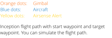
Orange dots:
Gimbal
Blue dots:
Aircraft
Yellow dots:
Airsense Alert


Reset your gimbal yaw to zero from the aircraft.
This is important for 360° missions and rescue
missions. Gimbal reset works with Inspire, Matrice
and Mavic aircrafts.
The panorama menu contains all values for a full-
spherical panorama mission. The values are
automatically adjusted to the focal length from
your aircraft. The settings supports zoom-lenses
(Mavic 2 zoom, Inspire zoom).
For Matrice 600 with MX Gimbal, Lightbride is sup-
ported with hdrpano 3D.
Hyperlight and Smart mode is supported for Mavic
2 Pro and Air 2 and Air 2S.
Take off and land with the inbuilt function if you
like.
The Airdrop button sends the actual drone posi-
tion in GPS waypoint format for Google Earth or
Apple Map to the rescue team. They can follow
the rescue position on their iOS or Android
devices with GPS.
The AE button is used to copy the camera's auto-
matic exposure settings to manual settings. It is
not currently supported for the Mavic 2 Enterprise
Dual. If you start the aircraft this function is
executed automatically.
The lens display informs about the currently used
focal length of the drone camera. Mavic 2 zoom
and Zenmuse X5 zoom lenses are supported.